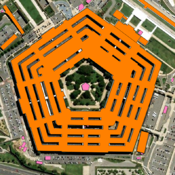
Discover

Fast Automatic, Global Geodata

Create maps 100x faster and 10x more economically

BrightEarth makes it easy for anyone to start generating map data.  Your business needs accurate, reliable and up-to-date map data to make critical business decisions. But generating 3D geospatial data has traditionally been challenging: 

  • Getting accurate, detailed 3D maps is expensive
  • Manually turning satellite images into map data takes weeks
  • Advanced mapping data is only really accessible to enterprises
  • Most organizations still rely on inaccurate open source maps

By combining decades of mapping expertise with LuxCarta's proprietary AI algorithms, BrightEarth delivers reliable maps directly from satellite imagery, at a fraction of the cost of traditional techniques.  We're democratizing access to map data for all.

Direct Access to Technology via API

Explore our API for seamless integration and limitless innovation

API BrightEarth

Explore our API for seamless integration and limitless innovation

Unlock the full potential of geospatial data with our BrightEarth API. Designed for developers, our API provides the tools you need to integrate detailed, accurate and real-time 3D map data into your applications and projects. 

Case study

Feeding VBS4 with BrightEarth

BI Simulations uses BrightEarth’s API as the input to Mantle, its customized terrain pipeline for simulation and training. Mantle is a platform that generates simulated terrain for training, mission rehearsal, visualization, and terrain analysis. BI Simulations uses BrightEarth to generate realistic, textured maps of real-world environments for the most up-to-date and meaningful simulations. 

Component 9 Capture d’écran 2024-04-03 à 09.59 2


Samples

GIS DATA

Select any location on the planet's surface - from a neighborhood, to a city up to an entire country - then tell BrightEarth what information you need about that place. It automatically generates an interactive 3D map you can start using in minutes.

CAD/3D

Download data in classic 3D formats (.obj, .stl, .dxf) for use in classic CAD engines such as Blender, MeshLab, AutoCAD

Synthetic Environement

BrightEarth's texturing engine gives you unparalleled accuracy, color balancing and realism. Through procedural texturing and geometric data augmentation, it generates realistic 3D synthetic environments, helps anyone visualize the corresponding land use, creates digital terrain models, and much more.

LuxCarta global BaseMap

BrightEarth's texturing engine gives you unparalleled accuracy, color balancing and realism. Through procedural texturing and geometric data augmentation, it generates realistic 3D synthetic environments, helps anyone visualize the corresponding land use, creates digital terrain models, and much more.

About LuxCarta

BrightEarth is powered by LuxCarta, one of the world's leading map data companies. We have:
  • Been digital mapping pioneers since 1989
  • Unparalleled knowledge, experience and understanding of digital mapping
  • Qualified, knowledgeable, expert teams
  • Responsive, global, and friendly customer support
Fichier 1 2
0

Offices across the globe

0

Years of experience

0

Customers

0

Employees

Get Started for Free

Group 7939

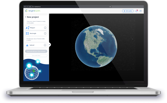
Discover how BrightEarth can transform your data into powerful insights. Start your journey towards smarter and more intuitive data analysis. If this is your first time, we invite you to explore the tool step by step.

To uncover the potential of the tool, we are offering you free credits.

Your welcome gift:

250credits